Article
Analysis of punctuality and driving times optimize journeys
Published 2021-06-02
Unpredictable events are a part of everyday life in public transport, but with analysis functions, we can optimize traffic punctuality in real-time.
In Gaia Public Transport’s Real-time Platform, it’s possible to get a snapshot of what’s happening in traffic. We oversee journeys, stops, and vehicles and can see deviations both on a general level over time and in detail during the current traffic day. With a map as the base for all information, data becomes easily accessible, and we can see correlations of geographic significance. This combined with information visualization that presents insights from real-time analyzed data, creates an easy-to-navigate overview of the traffic situation.
Real-time punctuality analysis
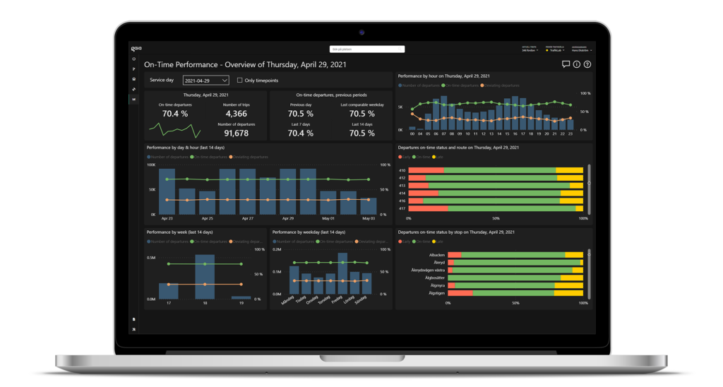
An area of analysis crucial for traffic authorities and operators is punctuality, which ultimately affects passengers’ trust in public transport. By analyzing vehicle arrival and departure times in real-time, we can create intuitive visualizations of when and at which stops vehicles are on time, early or late. Data from ongoing traffic is updated continuously, and the evolving diagrams show how traffic performs throughout the day. All real-time information is stored in Gaia Public Transport, allowing for comparing and analyzing punctuality over time. Hans Ekström, responsible for Data and AI at Gaia, describes:
“The information can be turned and twisted to analyze punctuality and driving times from various perspectives. For instance, you can see how a particular route or vehicle performs during the ongoing traffic day. This way, Gaia Public Transport can provide decision-making support for the operational management to act on immediately. The final result is presented in intuitive, visual, and interactive reports directly accessible in Gaia Public Transport’s platform.”

Visualization of punctuality analysis in Gaia Public Transport’s Real-time Platform.
Prediction of driving times
Another interesting area where we utilize vast amounts of data and advanced analysis in Gaia Public Transport is predicting driving times. The driving time between stops can vary depending on the day, time, and other factors. With custom analysis models, built with machine learning, we can detect deviations from the timetable based on current circumstances. We can forecast traffic conditions in real time by training the models on vast amounts of historical data. This enables optimizing forecasts for ongoing traffic, ultimately contributing to a better passenger experience.
“There are essentially no limits to what we can do with data in tracking and analysis in Gaia Public Transport. However, our purpose in providing this functionality is to make it as close to real-time as possible, and in some cases, even before it has happened. With that comes the need for machine learning and automating decision-making suggestions, as decisions must be made immediately. There – with that starting point – I believe we offer something new that the industry lacks today,” says Hans Ekström.
Since Gaia Public Transport uses open data, it’s easy to get started and directly apply the analysis functions to new traffic. Further, new analysis functions will be made available continuously, just as you’d expect from modern software. The development is progressing rapidly, and real-time analysis is an area you will see much more of in the future.
Gaia Public Transport is a cloud-based real-time system that gives you control over real-time information and content in public transport. Technology from various suppliers can collaborate by interconnecting the information flow in vehicles, systems, and traffic. It offers an overview and understanding of what’s happening during ongoing journeys. Gaia Public Transport isn’t tied to specific hardware or limited by space, making it cost-effective, easy to install, and easy to update. With intelligent visualizations and analyses, we improve public transport and make life easier for everyone involved.


